
Synopsis- The Karnataka Road Development Corporation Limited (KRDCL) is proposing to develop a 114 km elevated corridor in Bengaluru. The corridor will mainly be along the existing arterial roads, allowing fast travel that will be free of traffic congestion and will enable seamless freight movement. The proposed corridor intends to link several places along the city and will integrate with the metro and suburban rail systems. The elevated road system will reduce congestion and allow for a 30% to 50% reduction in travel time on the busiest and most dense corridors.
Design will include noise barriers, green bridges, and rainwater drainage, and attempts to minimize disruption to the environment. And as the city starts to witness the coming of this mega project, the real estate market around the developments are already seeing a surge in their values In this article, we are going to be talking about how the coming of this new project is going to change the real estate landscape of the city. But before all that, let’s first understand –
Why Bengaluru Needs Such Elevated Corridors?
Bengaluru, a tech hub, has long witnessed severe traffic jams along with rapid urbanization and chaotic growth. Its radial road system emanating from core business districts has all but been taken over by this traffic. Elevated corridors offer an efficient alternative to the expansion of surface roads or the extremely costly construction of underground metro extensions. What these corridors will do is, it will bypass bottlenecks in traffic, create better orbital connectivity, and provide faster access to emerging suburbs and central zones. Which will result in better economic efficiency, improved logistics connectivity, and improved commuters’ lives. The proposed plan for the corridor starts at various point close to the outskirts of the city, which are
1. North–South Corridor (NS)
- Connects: Airport Flyover (Esteem Mall) → Silk Board Junction
- Via: Jayamahal Main Road, Queen’s Road, Minsk Square, Kasturba Road, Hudson Circle, Audugodi Main Road
2. East–West Corridor 1 (EW-1)
- Connects: Battarahalli (NH-48/Old Madras Road) → Gorguntepalya (Tumkur Road)
- Via: KR Puram Bridge, Suranjandas Road, Indiranagar, Kensington Road, Ulsoor Lake, Mekhri Circle, Yeshwanthpur
3. East–West Corridor 2 (EW-2)
- Connects: Varthur Kodi (SH-35) → NICE Road (Mysore Road)
- Via: Kundalahalli, Marathahalli, Domlur, Richmond Circle, Lalbagh Road, Sirsi Circle, Nayandahalli
4. Connecting Corridor 1 (CC-1)
- Connects: Sarjapur Bridge (Aagara) → North–South Corridor
- Via: Jakkasandra, Madiwala Market, Koramangala 100 Feet Road
5. Connecting Corridor 2 (CC-2)
- Connects: D’Souza Circle (Richmond Road) → Ulsoor Lake
- Via: General KS Thimayya Road, Trinity Junction
6. Connecting Corridor 3 (CC-3)
- Connects: St. John’s Church Road → Outer Ring Road (Kalyan Nagar)
- Via: Wheeler Road, ITC Factory, Sevanagar, Banaswadi Main Road
Real Estate Consequences
- Increase in Peripheral Land Values: The areas of Sarjapur, Whitefield, Yelahanka, Devanahalli, Hoskote, and Bannerghatta Road are localities that are likely to be most affected by the new corridors. Ever since the announcement of the corridors, land prices in these localities have risen by 10-25%. The analysts predict a further rise of approximately 20-40% in the next 5-7 years when the proposed construction is in full swing.
- Learning from the Metro Influence: Earlier infrastructure announcements have actually always favored Bangalore real estate. Price appreciation of more than 10-15% was seen across the localities adjacent to the Metro expansion, particularly along the Purple and Green lines. The price appreciation impact of having an elevated corridor running parallel to the localities shall be at least that strong, if not then stronger, since it covers a larger stretch and is much faster to execute than the Metro lines.
- Decentralization of Urban Growth: The corridor allows moving away from a central city-oriented form of development into a more distributed, orbital kind. It can be home to massive opportunities for residential projects, plotted developments, and commercial zones being put up at the outskirts. Townships, smart gated communities, and industrial logistics hubs are expected to spring up along these routes, working as a catalyst for the emergence of several micro-markets within the metro region.
- Commercial and Industrial Development: Due to augmenting the linkage between the city and the Airport, the warehouse, logistics, hospitality, and business park sectors will benefit. Bannerghatta Road and Devanahalli are seeing institutional interest at present, with hospitals, IT firms, and developers buying land in anticipation of a surge in demand.
Challenges and Considerations
- Land Acquisition: The biggest single hurdle for the project is the land acquisition part. The erstwhile 93 km elevated corridor had faced delays and public backlash on the subject of acquiring over 1,000 buildings and huge chunks of private land. To ensure the success of the new 114 km version, the government must ensure some transparency and fairness, and legality from the very beginning.
- Environmental Concerns: Tree cutting has become an issue of concern, especially within the older Bangalore neighbourhoods. Another point to note is that the infrastructure construction in the rocky landscape of Bangalore could impair the natural drainage patterns and the underground water storage aquifers of the area. Appropriate interventions such as eco-bridges, tree replantation, and other ecological clearances should be in place.
- Cross Department Collaboration: There is a possibility for a political and administrative merger as the state government concurrently works on a 37 km tunnel corridor and metro line expansions. The public eagerly awaits the successful execution and timely delivery of the project, which depends heavily on inter-departmental collaboration and the structure of duties.
- Planning and Execution Phases: Currently, the project is undergoing the detailed planning and tendering phases. Execution will likely be done in prioritized sections, beginning with the Silk Board-Hebbal corridor and other key arterial routes. Each stage will consist of attaining 5-10 km increments in order to avoid excess disruption.
Also read: Jewar International Airport Set to Take Off – Will It Skyrocket Noida’s Real Estate Prices?
Real Estate Market Reaction
- Rise in Developers- Real estate developers have already begun acquiring land in anticipation of future growth. Several large-scale residential and commercial projects have been announced in East and North Bengaluru. Areas surrounding the corridor are expected to see rapid growth with gated communities, luxury apartments, and mixed-use developments.
- Rising Rental Yields- Being close to transport infrastructure drives not just prices but also rental yields. For example, the demand in areas around transport corridor intersections is already driving rental yield growth due to the requirements of professionals in the tech and logistics spaces.
- Integrated Township Projects- Developers will probably prioritize the development of self-contained townships, which combine housing and educational institutions and shopping facilities, due to the corridor’s connection to IT and industrial hubs. This is particularly appealing to middle-class families and NRIs looking for long-term investments.
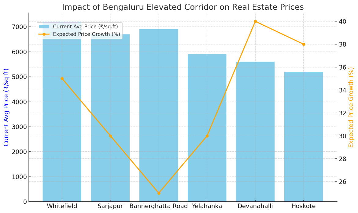
| Projected Real Estate Impact by Locality | |||||
| Locality | Proximity to Corridor (km) | Current Avg Price (₹/sq.ft) | Expected Growth (%) | Rental Yield Increase (est.) | Expected Demand Spike |
| Whitefield | 1.0 | ₹7,200 | 35% | 10–12% | High |
| Sarjapur | 0.5 | ₹6,700 | 30% | 8–10% | Very High |
| Bannerghatta Road | 1.2 | ₹6,900 | 25% | 6–8% | Moderate to High |
| Yelahanka | 1.5 | ₹5,900 | 30% | 9–11% | High |
| Devanahalli | 2.0 | ₹5,600 | 40% | 12–14% | Very High |
| Hoskote | 1.8 | ₹5,200 | 38% | 10–12% | High |
Conclusion
Bengaluru’s elevated corridor project is set to transform the city. Not only will it reduce traffic congestion, but it will also alter the real estate landscape by unlocking real estate opportunities where suburban links the countryside. While there are challenges such as acquiring land and environmental challenges, the eventual benefits to residents, businesses, and investors will be significant. If executed well, this corridor could transform urban mobility in Bengaluru, while being a guide for infrastructure-led urban growth for other Indian cities.
Written by Adithya Menon
